FREQUENTLY ASKED QUESTIONS
GUALE PRESERVE


GUALE PRESERVE
The St. Simons Land Trust is grateful to the many supporters who enabled the purchase of this historic and environmentally significant property, including the Georgia Department of Natural Resources (DNR), the U.S. Fish and Wildlife Service, family and corporate foundations, and hundreds of individuals. We are honored to play a role in preserving this important acreage for the benefit of the community and for future generations. Our staff and board remain focused on being good stewards of the land in our trust and being a positive force in the community. We have complied with all Glynn County requirements for infrastructure improvements, and we will continue to do so to ensure the safety and enjoyment of all who visit the property.
Below are some of the questions that have been asked about Guale Preserve on social media. If there are issues that you want further clarification on after reading the FAQ document, please call our offices (912-638-9109) and schedule an appointment with our staff. We are committed to being open and transparent and answering all questions to the best of our ability. Thank you.
What and where is Guale Preserve? This 258-acre property, portions of which were once known as Musgrove Plantation, was purchased by the St. Simons Land Trust in three phases in as many years, closing on the final phase in August 2018. The Preserve contains mature maritime forest, upland pine flatwoods, rare freshwater wetlands, and habitat for many species of native plants and wildlife. Guale Preserve is on the eastern side of Lawrence Road, just north of the Frederica Road/Lawrence Road roundabout on the island’s northern end. The Georgia Department of Natural Resources (DNR) holds a perpetual conservation easement on the property that prevents future commercial or residential development and ensures protection of the land forever.
How is the Preserve accessed? Currently, the main entrance is off Lawrence Road at Middle Road, a private road that leads to existing trails and fifteen (15) parking spaces, including one that is handicap compliant. From the parking area, visitors can hike or ride bikes in a 1.5-mile loop. The proposed second entrance is ¼ mile north on Lawrence Road via Village Drive. No fishing is allowed until improvements at the waterfront have been completed. However, visitors on foot can hike Janet’s Trail, a short path that loops through a forested area near the river. Visitors may also utilize the boat launch beginning Monday, April 10, 2023. Reservations can be made on our website.
Is there an existing road that runs through the 258 acres that would give access to the waterfront? No, there is not an existing road that can be used to drive to the waterfront. Instead, visitors can walk to the waterfront from Middle Road. However, at this time that would require going through forested areas where there are no existing trails.
What about something called “Contractors’ Road” that we have read about? Contractors Road, an old, dirt road within Guale Preserve has been claimed to be a waterfront access from Lawrence Road. While it does enter the northern section of the Preserve, it does NOT go to the waterfront. It also intersects with Cemetery Road that leads to Historic Village Cemetery, a private in-holding. In order for a waterfront route to exist off Lawrence Road, rare native plants, dense maritime forest, and wetlands would be compromised. The Land Trust would also have to put in a culvert and/or build a bridge over the existing drainage ditch north of Cemetery Road. There is no continuing route from Lawrence Road to the waterfront that does not encroach on the historic cemetery, trespass on other private property, or negatively impact the protected habitat.
I’ve read that the DNR is willing to amend the conservation easement held at Guale Preserve in such a way that would allow for a new route to the waterfront on SSLT property and that all the Land Trust must do is formally request the amendment. Is this true? No. We have had countless meetings with representatives of the Department of Natural Resources regarding alternate routes and the likelihood of changes to the conservation easement that they hold. The GaDNR has never amended a land conservation easement, and to set such a precedent would negatively impact important partnerships with other state and federal agencies. Altering the easement could also jeopardize future funding and the support of critically important coastal projects.
Is there lawful access? Yes. Village Drive has been a public road for nearly 100 years. It runs from Lawrence Road directly into Guale Preserve. Approximately half of the road was platted in 1922 and the other half in 1938. Roughly half of Village Drive from Lawrence Road running to the east, has a 70-foot right-of-way. The other half that continues from west to east has a 50-foot right-of-way. Glynn County government officials confirm that Village Drive is a public road.
Will the Land Trust be utilizing other neighborhood roads in the future? No. German Village and the public road that lies within it, Village Drive, is a unique situation. The Land Trust wishes to use Village Drive only to access the waterfront and provide opportunities for the community to enjoy Village Creek and Janet’s Trail which lie within this section of the Preserve.
Was a bridge removed by the Land Trust that could have been used as a road and provide access to the waterfront? No. At one time there was an earthen bridge crossing the tidal creek between what is now Guale Preserve and the Brenn Foundation’s property. There was also a wooden platform creekward of the land bridge. Both were irrevocably damaged by hurricanes Matthew and Irma. Over the years, a caretaker for the Musgrove estate had filled in portions of the tidal creek with tree trimmings and other materials as an attempt to stop erosion. It is important to note that even if the bridge had not been destroyed, the Land Trust could not use it. On the immediate opposite side of the creek, there is private property whose owners do not allow trespassing.
What about a culvert that was in the tidal creek? Did you remove that? No. The bridge mentioned above completely collapsed on the culvert during the past two hurricanes. The Land Trust received permission from DNR to remove the debris that had been previously dumped into the creek to stop erosion. But we were not allowed to disturb the creek bottom. The culvert remains in place today, even though parts of it are difficult to see because of silt and mud that has settled on top of it.
Who can decide what kinds of vehicles can go down Village Drive? This is a public road, maintained by the County. The same vehicles that can be driven on any public road should be able to use Village Drive. However, that is not a decision that can be made by the Land Trust.
Is it true that emergency vehicles will not be able to get down Village Drive if there are boat trailers being pulled by pick-up trucks? There are countless public roads in the county that are narrow but that support two-way traffic. Ambulances, fire trucks, and other vehicles always manage to drive down such roads and reach emergency situations. The same is true of Village Drive, which has a 50-foot right-of-way on half of it, and a 70-foot right away on the other half; both rights-of-way are owned by Glynn County. In addition, only five (5) boat trailers are allowed to enter the Preserve at any one time. Boaters must make prior reservations. Additional boats will not be allowed to access the waterfront and will not be able to park along Village Drive. Therefore, there will not be a string of boat trailers and other vehicles lined up to enter the Preserve.
Will the Land Trust cut down trees and widen Village Drive? Absolutely not. First, we want to preserve as much of the island’s tree canopy as possible, and we do not remove trees on our properties unless they are diseased, infested with insects, or create safety issues. We are in the business of SAVING trees wherever possible. At Cannon’s Point Preserve, for example, we have initiated research projects on reforestation, replacing dying pine beetle-infested trees with live oak seedlings. As stated previously, there is no need to widen Village Drive. Further, the Land Trust has no authority to do so and would never attempt to increase the size of a public road.
Is it true that the Land Trust is disturbing the shell middens at the Guale waterfront area by putting up a fence? No. We have installed a fence at the bluff east of Janet’s Trail as a proactive, preventative measure to PROTECT the middens. Over the years, people have used the creek bank there to enter the waterfront, causing the destruction of layers of shell middens. The fence is to prevent visitors from sliding down the bluff and entering the creek from the bank, which will continue to cause disturbances to the middens. The waterfront fencing was installed using techniques that have been implemented at Cannon’s Point Preserve. These techniques, recommended by archaeologists, create minimal disturbance in culturally/ archaeologically sensitive areas. Rather than digging large post holes, that scientists say destroy artifacts, the fence posts were anchored by rebar.
What sorts of activities can and cannot be conducted at Guale Preserve? Currently, the area accessed by Middle Road, the main entrance, is open to the public every day from 7:00AM to 5:00PM at no charge. Visitors can enjoy hiking, biking, birding, photography and other low-impact outdoor activities. Fifteen (15) parking spaces are available for visitors who enter this portion of the Preserve. No commercial activities can be conducted. At the Janet’s Trail section of Guale Preserve on the waterfront at the end of Village Drive, there are twelve (12) parking spaces for cars only. Here, visitors can enjoy hiking, biking, birding, and other low-impact outdoor activities. Visitors can also kayak, canoe, or launch small motorboats (not to exceed 20 feet in length) at the renovated boat launch beginning April 10, 2023. There are five (5) parking spaces for boat trailers. These five trailer spaces can be used and accessed only with advanced reservations that can be made via our website. Eventually, once safety and conservation improvements are made at the waterfront, it is our intent that visitors will also be able to use a family fishing platform. We are working with DNR and other partners in developing positive solutions that will enable county residents and visitors to utilize the waterfront.
We have read that the Land Trust has opened a new boat ramp at Guale Preserve’s waterfront. Is this true? No, there is no “new” boat ramp at Guale Preserve and there are no current plans to build a new boat ramp. There has been a boat ramp within the former Musgrove Plantation for many years. And, after meeting with engineers and environmental experts, it was determined that the existing ramp could be used if it were cleaned. The Land Trust received permission from the U.S. Army Corps of Engineers and Georgia DNR to remove silt and mud from the existing boat ramp. This work has been completed and the ramp is now open to launch kayaks, canoes, paddleboards, and small (less than 20ft) motorboats. Motorboats may only be launched with a prior reservation which can be made via our website.
May we walk our dogs on a leash at Guale Preserve? The conservation easement managed by the Department of Natural Resources does not allow dogs or other pets on the property. This is to protect the wildlife, habitat, and plants on the Preserve as well as ensuring the enjoyment and safety of other guests who are walking, hiking, biking, and visiting the property.
What about fishing on the property? Once the family fishing platform has been renovated and is safe for public use, fishing will be allowed on Musgrove Creek.
A public notice was posted recently at the entrance to the Guale Preserve waterfront in regards to a permit request by the SSLT for a new fishing dock on Musgrove Creek. Social media posts claim that the new floating dock is much larger than the previous stationary fishing platform and encroaches farther into the creek than was previously proposed and that this new construction was not included in the original park permit. The public notice was posted by the GA Department of Natural Resources (DNR) for a FIXED family fishing platform permit at Guale Preserve. It is a replacement for a dilapidated crabbing dock that was destroyed by Hurricane Irma. As the public notice states, the replacement will be a fixed T-platform, not a floating dock. The proposed family fishing platform is larger than the previous dock in order to ensure maximum safety for those using the platform, including children and the disabled. The permit request states that “the fixed T-head fishing platform will be positioned to not unduly extend into the waterway” but extends only to reach water for fishing across the tide table; distance of the platform from the channel is 43 feet. The upland component of the platform is located within the 50-foot marsh buffer. The marsh buffer will be left pervious and natural except for the portion of the concrete access pad to accommodate wheelchairs at the entrance to the walkway of the fishing platform. This structure was NOT included in the Preserve infrastructure permit to the county because it is over state water bottoms and is not under the permitting purview of Glynn County. County officials signed off on the plans (a requirement of the Coastal Marshland Protection Act) as confirmation that the request was not contrary to existing zoning. That required sign-off was Glynn County’s only involvement.
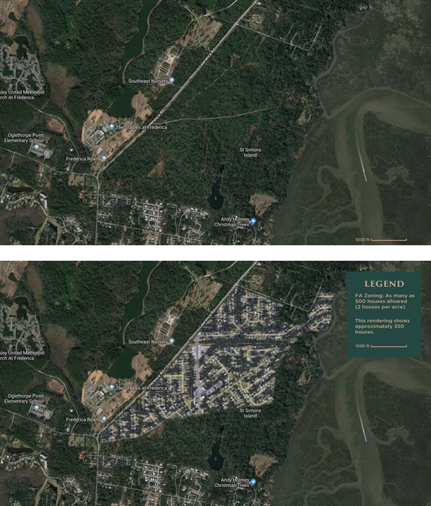
What is the zoning at Guale Preserve? The zoning is Forest Agricultural (FA). This zoning classification is for recreational and other public purposes. The specific permitted uses include wildlife refuge, forest management, or use by any philanthropic institutions such as the Land Trust, according to Zoning Ordinance, Section 704.1. NOTE: Other permitted uses under FA, Sections 704.2 and 704.3, include two houses per acre, two mobile homes per acre, a dredging or landfill operation, a go-kart track, and a host of other conditional uses that would not be beneficial to a nearby neighborhood.
We have heard that the Brenn Foundation would never have sold part of Musgrove to a developer. How can the Land Trust claim it saved the area from being ruined by the construction of as many as 500 new houses?
There have been countless meetings and conversations between representatives of the Brenn Foundation and the St. Simons Land Trust. There is no question that significant portions of the former Musgrove Plantation would have been developed if the Land Trust had not acquired and protected the property. The property is zoned F/A (Forest/Agriculture) which allows the construction of two houses per acre. With 258 acres, as many as 500 homes could have been built. In addition, the pressures on island infrastructure (water/sewer, traffic, etc.) would have increased dramatically. Land planners use as a rule of thumb, an average of two cars per household with those cars making as many as five roundtrips a days. Using this formula, there could have been an additional 1,000 vehicles on Lawrence Road/Frederica Road every day, some making multiple trips, greatly impacting the entire north-end of the island and all who travel along Frederica Road.
Images to the left show Guale Preserve in its protected state (top) versus a rendering of how it could look if sold to developers (bottom).
What were your dealings with Glynn County? We have heard terms like “collusion” between you and the County staff. Before we submitted any plans, we met with County staff and talked with them about the improvements we were proposing. We asked how they interpreted various provisions of the zoning ordinance and about their position regarding Village Drive as a public road. As with most property owners, we tried to learn everything we needed to know to inform our decisions and to submit a responsible request. Even though we learned that no plans or permits were required for the requested “infrastructure only” improvements, we asked our engineer to submit plans to make certain that we were crossing all t’s and dotting all i’s and being completely transparent. Our dealings with the County have been professional and at arm’s length. We never held solo, one-on-one meetings with any County staff member but always included representatives of the Planning & Zoning Department, the County Attorney’s office, and representatives of other relevant departments, such as Engineering and Traffic.
Was a building permit required for the accessory/storage structure at the waterfront? No. There is a walking trail at the north-end/waterfront area of the property called Janet’s Trail. At the trailhead, we have installed a gazebo-type structure with storage under the seating. This open-air gazebo is less than 120-square feet in size with four corner posts, a roof, and benches between the corner posts. The structure is not visible to residents of German Village or from Village Drive. Neither the gazebo nor the five parking spaces at the waterfront required a permit. Instead, we asked for the County’s approval for these improvements and received it.
Was a site plan required? No. A site plan is needed only when a building permit is required for the following types of development: 1) commercial uses; 2) industrial uses; 3) multi-family uses; 4) non-residential uses in residential zoning districts. The Land Trust was specifically told by Glynn County officials that NO site plan was required.
We have read that “the boat ramp, trailer parking and the 12 additional parking spaces were not on” the original infrastructure request that was approved by the Glynn County Commission. Is this true? Improvements consisting of parking at the main Preserve entrance (at Middle Road), parking to serve both Janet’s Trail at the waterfront and eventually the boat ramp, and a trailhead/storage structure were on the original permit request, and permission was given on that request in 2018. The Glynn County Board of Commission upheld that permission in 2019. The 12 additional parking spaces were not on the construction request to Glynn County as we were advised that a permit was not required since there was no construction conducted for the 12 dirt/grass parking spaces. The boat ramp was not on the original infrastructure request because it already existed.
We have read on social media that you are dredging the marsh at the Guale Preserve waterfront. Is this true? No. we are not dredging the marsh or creek and have no plans to do so.
Why was there not a publicly noticed Letter of Permission to bring heavy equipment to Musgrove Creek when you started removing the mud? Neither a PCN nor a Letter of Permission were required by federal and state regulatory agencies to clean the boat ramp. Mud was removed from the footprint of the existing ramp.
Did you prevent residents of German Village from taking photos of the recent waterfront mud removal process? The Land Trust has not prevented anyone from accessing or photographing any portion of Guale Preserve that is open to the public during regular operating hours. The only times the gate has been closed during normal operating hours was when work has been conducted to ensure everyone’s safety. Those areas of Guale Preserve that are not yet open to the public are not accessed for any purpose.
We have read on social media that the Land Trust is a developer, and that you are going to develop the waterfront into a major park. The St. Simons Land Trust is an accredited member of the national Land Trust Alliance and is an IRS-approved, 501(c)(3) nonprofit organization to which supporters can make tax-deductible contributions. We were established in 2000 to prevent development of environmentally, historically, and culturally significant properties on the island. We are in NO way a developer, and we have no plans to develop any of our properties, including Guale Preserve. Over the past nearly 20 years since this community organization’s founding, its board, staff, volunteers, partners, and donors have worked tirelessly to stem overdevelopment and congestion and to save as many properties as possible. During that time, we have acquired and protected more than 1,000 acres of land on the island.
I have read that the R-6 zoning of German Village does not allow ‘commercial parks’. Is Guale Preserve a ‘commercial park’? No commercial enterprises are part of Guale Preserve. In fact, the Conservation Easement clearly states that “industrial and commercial activities are prohibited on the Property.” Instead, the Preserve is a place for the public to use for low-impact activities at no cost. Guale Preserve is not a park; it is a carefully managed wilderness preserve.
We have seen photos on social media of a Sea Island-owned van entering Guale Preserve. Will tour buses be allowed on the property? The Sea Island Company has NOT conducted any bus tours of the Musgrove/Guale Preserve property. In late 2017, the Land Trust rented a Sea Island van to take a few supporters on a site visit to some of our properties. The Musgrove/Guale Preserve property was one of the properties visited, and a photograph was taken of the vehicle entering the waterfront area of the future Preserve. There will be NO commercial enterprises created at Guale Preserve. This is a privately owned property that will be monitored by a perpetual conservation easement that will never allow its development or overuse.
What are your future plans? We have cleaned the mud and silt from an existing boat ramp after receiving permission from the U.S. Army Corps of Engineers and Georgia DNR. The former boathouse has been repurposed to serve as a family picnic and education pavilion that will include interpretive signs. A handicapped-accessible, child friendly fishing platform will replace a storm-damaged platform to the south of the picnic pavilion and boat ramp. These facilities have been on the property for decades but have been seriously damaged or destroyed by age, use, and storms. We will submit all required plans before these improvements are made and go through all permitting requirements that apply.
I have read on social media that the Land Trust will be purchasing Phase 4 of Musgrove, which could eliminate the need to use Village Drive as an entrance to the waterfront. Is this part of your future plans? There was a provision in the National Coastal Wetlands Grant application that stated: “The acquisition of Phase 4 will take place in the following year, and will mirror the approaches of Phases 1, 2, and 3.” Although this was stated, and while the Land Trust has a right of first refusal on Phase 4, it is NOT currently for sale and it is the understanding of the St. Simons Land Trust that the owners have NO plan to offer Phase 4 for sale in the near future.
In addition, we read that the Land Trust has “ignored pending court hearings on the ownership of the disputed dirt easement.” While there is pending litigation against the Land Trust and Glynn County from a resident of the Village Bluff neighborhood, there was no “stay” on the use of Village Drive or the dirt section at the end of that public road that the litigant claims is her personal property. The Land Trust has followed the directives of the Court and County officials on all matters regarding use of this public road and making improvements to its private property and has been told repeatedly by the Glynn County Commission that permission has been given to use the road, including the dirt section leading into the waterfront area of the Preserve.
Why did you install a gate with a keypad at the end of Village Drive? Isn’t this dirt easement still tied up in the Court of Appeals? No, the dirt easement is not tied up in the Court of Appeals. There is pending litigation against both the Land Trust and Glynn County regarding the dirt easement (see above), but there is no limitation on its use as a public road. The electronic gate, which is on Land Trust property, not the area in question, was installed so that the waterfront could be closed at night for the safety of visitors and so as not to disturb neighbors when the Preserve is closed. An electronic gate with a keypad is also at the Middle Road main entrance to the Preserve for the same reasons.
Has the Land Trust removed German Village residents’ “Save German Village” signs? Absolutely not. We have never asked for the residents’ signs to be removed and have never removed them ourselves. When social media posts stated this, we researched the source and learned that Glynn County workers removed the signs from the county-owned right-of-way and told residents that the signs could be replaced, but only on their private property – not on the county right-of-way.
I read on social media that the Land Trust asked the Glynn County Joint Water and Sewer Commission to add a new water (and future sewer) line down Village Drive. Is this true? The St. Simons Land Trust is not at all involved in the Joint Water and Sewer Commission putting lines in the German Village neighborhood or anywhere else. Additionally, we have NO need for water and sewer lines to be installed for Guale Preserve or any of our other properties.
What is the Pennies for Preservation Program and why are people asked to participate? This is a completely VOLUNTARY giving program. Our participating business partners believe in the mission of the Land Trust and want to help protect the island’s natural resources and its most iconic and important features. When patrons visit one of these partners, they have the opportunity to contribute 1% of their bill to support land acquisitions and conservation efforts. If the cost of dinner is $75.00, say, 75 cents would be added to a receipt. However, since this is a totally voluntary option, patrons can simply request that the 1% donation be removed from the bill. Currently, the program’s contributions have been earmarked to help pay for the Oatland North/ Hasell Property purchases.
Why did the Land Trust remove the historical road marker about German Village? Neither the Land Trust nor its representatives removed ANY historical markers or signage about German Village. It is our understanding that the marker was moved to the opposite side of Lawrence Road by the County so that those on the bike path could read the sign.
Visit the Guale Preserve Waterfront (Village Drive) to enjoy the newly installed Family Fishing Platform!