ARTIFACT ANALYSIS
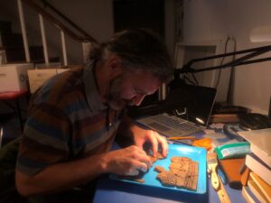
Scott Clark, a Georgia Southern University graduate student is working to learn more about Native American life at Cannon’s Point Preserve.
The St. Simons Land Trust is partnered with the Coastal Georgia Historical Society which has an archaeology lab that houses all artifacts from Cannon’s Point Preserve since it’s purchase in 2012. Currently, Scott is working in the lab to help with analyzing data from Cannon’s Point. He has recently been working on putting together a 4,000 year old Native American pot which was discovered during the 2016 dig at the Preserve restroom site.
LATE WOODLAND PERIOD SUBSISTENCE ON GEORGIA’S COAST: FAUNAL REMAINS FROM TAYLOR’S FISH CAMP, ST. SIMONS ISLAND
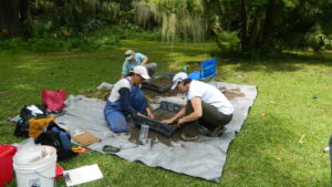
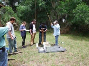
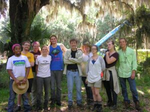
Georgia Southern University graduate student Scott Clark has been conducting his master research at the Preserve. Scott completed his archaeological fieldwork at Cannon’s Point Preserve for his masters thesis project in the summer of 2018. With help from local volunteers and Georgia Southern students, he excavated a portion of a prehistoric shell midden near the old Taylor’s Fish Camp at Cannon’s Point Preserve.
His research is focused on the subsistence practices of Native Americans who occupied the peninsula during the Late Woodland period (ca. 1500 – 1000 B.P.). The project included fine-mesh screening techniques not typically used during archaeological excavations. These methods are designed to capture very small artifacts and animal bones which often fall through the commonly-used larger screen sizes. Preliminary analysis reveals a diet which focused heavily on aquatic resources, especially shellfish and fish. Faunal remains recovered from the Native American deposits include oysters, clams, ribbed mussels, periwinkle, crab claws, turtle shell, drum teeth, gar scales, and catfish otoliths (inner ear bones). Native American pottery sherds were also recovered from the midden. Laboratory analysis will continue.
DECEMBER 2018 UPDATE:
“Analysis of materials recovered during recent excavations at Taylor Fish camp is ongoing. Nearly all identifiable types of Native American pottery are associated with the Late Woodland period (c. 500 – 1000 AD) and the Early/Middle Mississippian period (c. 1000 – 1300 AD). A few pottery sherds show evidence of artistic stamping on the exterior of the vessel.
Thanks to the generous support of members of the Coastal Georgia Historical Society, we were able to radiocarbondate materials from my excavation and previous excavations at Taylor Fish Camp. Results confirm what we expected and align with the pottery types. The earliest date (about 780 AD) came from a piece of charcoal in a shell midden, and the latest date (about 1280 AD) from charcoal in a nearby trash pit. A charred deer bone from another nearby pit dated to about 1050 AD. Results show that most of the shell, animal bones, and pottery sherds from my excavation were deposited around 900 to 1100 AD. These carbon dates, combined with other evidence collected in the area, have shown that people have been living and using resources at Cannon’s Point for over 4000 years.
Analysis of faunal remains from my excavation and a previous excavation will shed light on subsistence practices during the Late Woodland period. So far, identified mollusc species include eastern oyster, hard clam, ribbed mussel, stout tagelus, and periwinkle. Fish species include gaftopsail catfish, hardhead catfish, mullet, drum, and flounder. Other interesting finds include a gar scale, numerous fish otoliths (inner ear bone), catfish spines, hundreds of fish vertebrae, a piece of a crab claw, and a well-preserved pearl. There are also a good number of turtle shell fragments, many of which look to be diamondback terrapin. These results are indicating a heavy focus on estuarine resources, especially fish and shellfish.”
JUNE 2019 UPDATE:
“Identifications of ceramics and faunal remains from the 2018 Taylor Fish Camp excavation are complete. The pottery types are associated with the Late Woodland (c. AD 500 – 1000) and Early/Middle Mississippian period (c. AD 1000 – 1400). Results of radiocarbon dating from multiple locations around the site confirm those dates, showing the Taylor Fish Camp area was used heavily during that time. I looked at over 30,000 pieces of invertebrate and vertebrate remains discarded by Native Americans during those periods. Common invertebrate species were eastern oyster, clam, ribbed mussel, stout tagelus, along with smaller numbers of whelk, periwinkle, and a few pieces of crab claws. The animal bones were almost entirely from turtles and fish. The most common fish were saltwater catfish, mullet, and killifish, with smaller numbers of flounder, menhaden/shad, sheepshead, and several species of drums such as trout, redfish, stardrum, and croaker.
The next step is to continue analysis by quantifying the results in several ways and figuring out what it all means! The use of fine-meshed screens while excavating is giving us a more accurate picture of subsistence practices by showing that small-sized fish were an important part of their diet. All the fish species identified could be captured very near the site location and likely required traps and nets. A final report will be finished by the end of [2019].”
DECEMBER 2019 UPDATE:
Scott Clark successfully defended his master’s thesis this past fall at Georgia Southern University. Scott was able to provide the below update on the conclusion of his research.
“The Georgia Southern University master’s project on Native Americans living at Taylor Fish Camp is complete. The types of pottery sherds, radiocarbon testing, and structural evidence, show that the site was heavily-occupied from approximately the 8th to the 13th century. Animal remains collected during excavations in 2014, 2016, and 2018, reveal that subsistence strategies focused heavily on shellfish and shallow-water fish. By attempting to identify over 30,000 fragments of shell and bone, I was able to gain an idea of the most commonly-used resources. The types and sizes of species identified also help us to understand the most frequently targeted habitats, the time of year they were captured, and the technology used to capture them.
Shellfish consisted of mostly stout tagelus and oyster, followed by ribbed mussel, hard clams, periwinkles, and eastern mud snail. The vertebrate bones excavated from the site were almost entirely fish and diamondback terrapins. Mammals such as deer, raccoon, and opossum were present but in low numbers. Catfish were the most dominant fish, followed by mullet and multiple species of drum, menhaden/shad, flounder, sheepshead, and stingrays. The use of very small archaeological screens indicate that killifish (mudminnows) and fingerling mullet were caught in large numbers. All the fish identified could be caught in the estuaries surrounding the peninsula, especially during the warmer months. Mass-capture methods such as traps and nets were likely used. Comparison with other studies in coastal Georgia suggest similar lifeways, as prehistoric residents focused on the same group of resources, with only slight differences related to site location. I am grateful that St. Simons Land Trust allowed me to carry out this project and look forward to more research at this unique location.”